Showing posts with label MOUNTAINS. Show all posts

12 December 2022 - ANCIENT WATER CHANNELS ON MOUNTAINS in SWITZERLAND


ANCIENT WATER CHANNELS 

ON 

MOUNTAINS in SWITZERLAND 


G'day folks,

Medieval irrigation channels built into the sides of mountains provided Valais with water for hundreds of years.  

Some of the best places to hike in the state of Valais in Switzerland are ancient pathways that once used to bring water down from mountain streams to farms in the valleys and meadows below.

The creation of these channels, known as bisses, goes back at least as far as the 14th century, though some believe those medieval routes were built where Roman channels had previously been. In the aftermath of the Black Death in the mid-1300s, with a significantly reduced population across Europe, the grain fields in Valais were repurposed to grow hay to raise cattle for the rising demand of beef across the border in Italy.


Owners of the fields and pastures pooled their resources to build bisses for irrigation, which was more necessary than it had been for growing grain. A lot of resources were needed, since many of the bisses were built into the sides of mountains and cliffs, which made digging them particularly dangerous hundreds of years ago. They tended to be between 5 and 10 kilometers, though a few stretched more than 20 kilometers.


Over time, they came to be used by vineyards and orchards in the area as well. Those more wealthy landowners, who controlled the water supply, arranged for systems allowing the use of the water by the smaller farmers. The smaller farmers and their families, in turn, helped maintain the bisses, cleaning and repairing them every spring. Canal guards, who lived in cabins along the channels, kept regular watch over the flow of water, making sure it was not interrupted.

For the most part, the bisses that remain have become scenic tourist attractions and inspired hiking trails, though some are still in use. Some of the trails run alongside the bisses, but others are the bisses themselves, repaired and reinforced. Le Musée des Bisses offers a convenient itinerary of some of the most spectacular bisse-adjacent trails, the bisse of Sion, the bisse ‘Ayent, and the Bitailla, in addition to exhibits on the history of the Valais bisses.

The address and coordinates above are for the museum, which provides a good launching point for many hikes through the bisses.

25 September 2022 - THE CHURCH IN THE SKY - ETHIOPIA


THE CHURCH 

IN THE SKY

 - ETHIOPIA -


G'day folks,

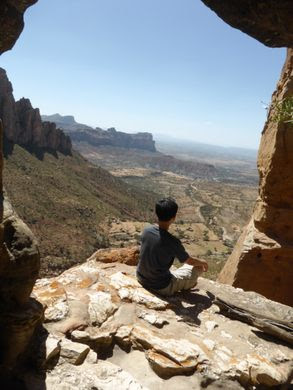
Reaching the "Church in the Sky" requires scaling the cliff face of a sandstone pinnacle with a 650-foot drop. 

If you think going to a normal church can be an enlightening experience, imagine going to worship in a rock-hewn painted cave atop a towering sandstone pinnacle, only reachable via a daredevil climb with 650-foot drops on all sides. 


At Abuna Yemata Guh in northern Ethiopia, this risky and thrilling experience is common practice for a few dedicated priests. The monolithic place of worship is said to be the world’s most inaccessible and dangerous church, reachable only by a 45-minute ascent.

The journey has cliff faces to scale, rickety bridges to cross, and narrow ledges to traverse. After crossing through the valley that underlies the church, you must ascend the half-mile-high sandstone pinnacle, searching for rare footholds to avoid the long drop. Adding to the general sense of dread, the route passes by an open-air tomb filled with the skeletal remains of deceased priests (although it’s said that none of the priests died from falling off the cliff).

If the intense climb and the gorgeous view of the valley below aren’t enough to take your breath away, the interior of the church surely will. The cave’s ceiling is covered by two beautiful frescoes, featuring intricate patterns, religious imagery, and the faces of nine of the twelve apostles of Christ. The church also contains an Orthodox Bible with vibrant, colorful sheets made of goatskin. Abuna Yemata Church is so sacred that some Ethiopian parents even risk bringing their babies all the way to the top of the cliff to have them baptized there.


The church is named after Father Yemata, a priest who carved the church out of the cliff face in the 5th century. Some say he chose the high location to escape enemies, while others believe it was an attempt to find true divinity. Either way, his rock-hewn masterpiece has provided a unique opportunity for Ethiopian Christians to demonstrate their commitment to their faith in epic fashion.

21 July 2022 - DEVIL'S SLIDE TRESTLES - COLORADO


DEVIL'S SLIDE TRESTLES 

- COLORADO -


G'day folks,

These decaying bridges 1,000 feet high are a reminder of the skill it took to cross the Colorado Rockies by rail. 

Built in 1905 at a total elevation of 11,600 feet on the edge of South Boulder Canyon in the Colorado Rockies, the Devil’s Slide Trestles cling to the side of a mountain with only oblivion between them and the waters of Middle Boulder Creek nearly 1,000 feet below. 


The twin train trestles were part of a harrowing and dangerous railroad that climbed up and over the Colorado Front Range to connect Denver to Winter Park and Salt Lake. This route was part of the historic Moffat Road, one of the highest standard-gauge, non-cog railroads built in the United States. For two decades, the trestles provided an unnerving passage to passengers of the Denver & Salt Lake Railway, until the route was abandoned in 1928 with the opening of the 6.3-mile Moffat Tunnel.

In 1955, the road was opened to automobile traffic following the removal of the train tracks in 1938. But this did nothing to alleviate the unsettling experience of crossing these high bridges. Following the collapse of a tunnel in 1990, the trestles, decaying from nearly 100 years of Colorado’s extreme weather, were closed to automobile and pedestrian traffic. Today, the trestles are not safe to cross, but can be seen by hiking or mountain biking the trail out to the site from either the east or west side of the pass. Looking at the twin trestles you can imagine what it was like to traverse these rickety bridges, with nothing but air between you and the cold waters of Middle Boulder Creek.


3 June 2022 - THE CHOCOLATE HILLS OF BOHOL, PHILIPPINES


THE CHOCOLATE HILLS

 OF BOHOL, PHILIPPINES


G'day folks,

Welcome to Bohol's mysterious brown hills. 

Were you to fly over Bohol Island in the Philippines during the dry season, you might notice what looks like thousands of chocolate kisses protruding from the terrain.

These mysterious conical mounds are known as the Chocolate Hills. There are approximately 1,268 individual hills, their heights ranging from 100 to 160 feet, though the highest is almost 400 feet high. The hills, which are almost all symmetrical, consist of grass-covered limestone and turn brown during the dry season.


Despite the abundance of hills, it is unclear how they were formed. There are multiple geological explanations ranging from oceanic volcano activity to limestone weathering. A recent theory is that an ancient volcano self-destructed and chunks of it were dispersed over the region.


Numerous legends and tales also exist to explain the Chocolate Hills. One is about a giant buffalo who came and wreaked havoc in the region, eating and destroying all the crops. As an act of vengeance, locals left out spoiled crops. When the buffalo ate them it got sick and left mounds of feces in its wake, bringing new meaning to the name “Chocolate Hills.”

3 April 2022 - CANDY CANE MOUNTAINS


CANDY CANE

 MOUNTAINS


G'day folks,

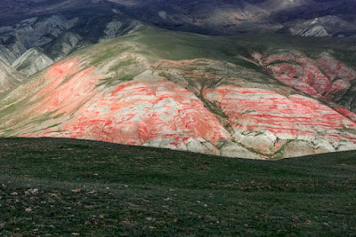
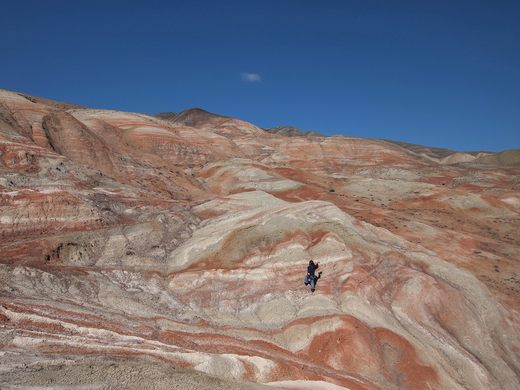
Swirling layers of white and red rock earned these mountains their festive nickname. 

On the highway between Baku and Quba in Azerbaijan, a series of red-and-white striped peaks emerge suddenly from the surrounding landscape. Part of the Greater Caucasus mountain range, the Candy Cane Mountains earned their nickname thanks to their striking resemblance to the classic Christmas treat.


The color of these rocks is a product of the area’s unique geology. The Candy Cane Mountains are made of shale, a type of sedimentary rock made up of many thin layers stacked on top of each other. Long ago, before the rock was formed, changes in the environment led to differing mineral composition as the layers of sediment were deposited.

As the shale came in contact with water, layers that contained iron oxidized and turned red, while layers without iron remained shades of white and gray. Over time, tectonic movement and erosion have exposed these sedimentary layers into a visual representation of geologic history. The Candy Cane Mountains also contain many belemnites, fossils of an extinct order of squid-like creatures from the Cretaceous period.

Clancy's comment: Ah ... the wonders of nature, eh?

I'm ...


10 January 2022 - SPECTACULAR PU CHI FAH - THAILAND


SPECTACULAR PU CHI FAH

 - THAILAND -


G'day folks,

 This mountain sunrise is one of the most breathtaking views in Thailand, yet well off the tourist trail. 

Phu Chi Fah is a must for anyone seeking the perfect sunrise experience. Located on the Thai/Lao border, this mountainous area is several degrees removed from the mass tourism Thailand is known for. It is quite far (almost 60 miles) from the nearest city, Chiang Rai, and there are hardly any other sights in the vicinity. And let’s not forget that in order to get to the peak before dawn, you need to wind up and down rural roads in the dark. Yet, it is well worth it.


 Once you’ve reached Phu Chi Fah before the sun rises, darkness begins lifting, and most days a thin layer of mist appears from the lowlands, forming a bed of fluff through which the higher hilltops peek through. This is the signature view of the Phu Chi Fah sunrise. Once the mist begins lifting, the view opens up, revealing forests, hills, valleys, farmland and the mighty Mekong River all the way to Laos and beyond. And above it all, colorful hues and shades turn the sky into an ever-changing work of abstract art.

The beauty of the Phu Chi Fah sunrise appears in many tourist brochures and posters, but its name is rarely mentioned, which also goes to explain why so few visitors make it here—that is international visitors, as Thai locals are very fond of this place. The Phu Chi Fah viewpoint is the top of a steadily rising mountain that terminates abruptly with a dramatic drop. The most photogenic spot is just before you arrive at the top, so that both the cliff and the misty blanket are in sight.

Clancy's comment: I can speak from experience about this area. In fact, it is mentioned in my current book. Sunrise and sunsets are stunning. 

I'm ...


30 July 2021 - MOST DANGEROUS TRAIL IN THE WORLD


MOST DANGEROUS 

TRAIL IN THE WORLD


G'day foks,

There is a mountain located in China called Mt. Huashan, and plenty of people have died on this mountain. 

One look at these pictures and you’ll see why. There is a hiking trail that has been dubbed as the world’s most dangerous hiking trail which reaches a height of 7,087 feet high. It has a nickname of “The Heavenly Stairs.”

The paths have been reinforced due to a recent influx of tourists, but they are nonetheless dangerous, and carry a reputation for fatal falls. Although no official statistics are kept, some say that the number may be as much as about 100 fatal falls a year. Some of the more dangerous parts of the trails have names like Thousand-Foot Precipice, Hundred-Foot Crevice and Black Dragon Ridge.


Clancy's comment: And it leads to a Taoist temple! Definitely not for me.

I'm ...