Showing posts with label FORMATIONS. Show all posts

6 April 2022 - ELEPHANT ROCK - ICELAND


ELEPHANT ROCK

 - ICELAND -


G'day folks,

On an island south of Iceland, a large volcanic rock formation resembles an elephant. 

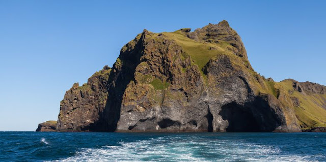
Vestmannaeyjar (Westman Islands) is a small archipelago just off the southern coast of Iceland. The largest of these volcanic islands is called Heimaey, which features various quirky rock formations.

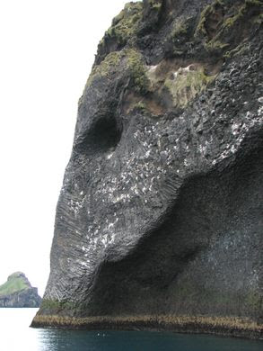
The most outstanding rock formation on this island can be found along the western coast and is shaped like an elephant head, with its curious appearance resembling a pachyderm with the trunk being positioned under the Atlantic Ocean.


Known as Elephant Rock, it was formed by one of the many volcanic eruptions of Mount Eldfell, the main volcano on the island. The last eruption occured in 1973, when half of the town of Heimaey was destroyed, but the rock is believed to be much older. The volcanic basalt is wrinkled in a way that resembles elephant skin. The appearance of the rock has also been compared to Cthulhu, the mythical sea creature featured in H.P. Lovecraft’s works.

Elephant Rock is located on the lower part of a rocky area of the island with steep cliffs and can only be reached by a one-hour boat tour. While on the island, visitors can find many other incredible volcanic formations and a diverse bird population, including the largest puffin colony in the world.

Clancy's comment: Nature has a wonderful way of entertaining us.

I'm ...


3 April 2022 - CANDY CANE MOUNTAINS


CANDY CANE

 MOUNTAINS


G'day folks,

Swirling layers of white and red rock earned these mountains their festive nickname. 

On the highway between Baku and Quba in Azerbaijan, a series of red-and-white striped peaks emerge suddenly from the surrounding landscape. Part of the Greater Caucasus mountain range, the Candy Cane Mountains earned their nickname thanks to their striking resemblance to the classic Christmas treat.


The color of these rocks is a product of the area’s unique geology. The Candy Cane Mountains are made of shale, a type of sedimentary rock made up of many thin layers stacked on top of each other. Long ago, before the rock was formed, changes in the environment led to differing mineral composition as the layers of sediment were deposited.

As the shale came in contact with water, layers that contained iron oxidized and turned red, while layers without iron remained shades of white and gray. Over time, tectonic movement and erosion have exposed these sedimentary layers into a visual representation of geologic history. The Candy Cane Mountains also contain many belemnites, fossils of an extinct order of squid-like creatures from the Cretaceous period.

Clancy's comment: Ah ... the wonders of nature, eh?

I'm ...


16 January 2022 - RED ROCK COULEE - ALBERTA, CANADA


RED ROCK COULEE 

- ALBERTA, CANADA -


G'day folks,

Here, you will find huge spherical rocks in the middle of the prairie.  

Dotting the pristine prairie hills of Southern Alberta, these large and exceptionally spherical red rocks make it feel as though you’re standing on Mars. Some of the fiery-hued boulders are over 8 feet across (2.5 meters), putting them among the largest sandstone concretions in the world.


 This geological oddity can be a little tricky to get to, just enough off the beaten path to keep the area remarkably quiet, only adding to the otherworldly feel. Red Rock Coulee is about 30 miles (50 kilometers) southwest of the city of Medicine Hat, and although it’s not really on your way to anywhere, this detour or day trip is an interesting sight.

You can climb the large rocks and marvel at the mystery of their formation. One of the spheres is split clean in half, showing off its strange shape. The concretions have eroded out of the soft bedrock that blankets the area, and turned red from iron oxide. If you’re in luck you can study the unique quartz crystals you can find in the area, while taking in the beautiful sunrise or sunset over the colorful badlands landscape. 

Clancy's comment: Weird, eh? That's nature.

I'm ...


6 December 2021 - STUNNING SAN JUAN BASIN in NEW MEXICO


STUNNING SAN JUAN

 BASIN in NEW MEXICO


G'day folks,

The land is full of geologic eye candy like otherworldly spires, mushroom-shaped hoodoos, and prehistoric fossils. 

With its muted colors and striking geology, this unusual landscape feels like a martian planet. Pale, mushroom-shaped hoodoos loom above the rocky earth like enormous alien trees. Petrified tree stumps and ancient bones speckle the badlands like prehistoric markers of its long-gone inhabitants.

Located in the arid San Juan Basin of northwest New Mexico, the Ah-Shi-Sle-Pah Wilderness Study Area is located on 6,563 acres of public Bureau of Land Management land. It’s a hidden wonder of weathered rock formations often referred to as hoodoos (not to be confused with witchcraft or the evil eye), tent rocks, fairy chimneys, earth pyramids, or mushrooms.


 Geologically, the area is comprised of layers of sandstone, shale, mudstone, and bituminous coal that were deposited 75 million years ago during the late Cretaceous era. A whopping 75,000 millennia of wind, water, and ice weathering and eroding the layers are responsible for the surreal and alien-esque landscape.

Because of its geologic age and climate, the area is rich with animal and plant fossils. The remains of prehistoric crocodiles, turtles, fish, and dinosaurs are sprinkled throughout the land. You’ll also see petrified wood, including numerous upright tree stumps with roots. Fossils are not allowed to be collected.


 While it’s somewhat challenging to get there, visitors are rewarded with a tranquil, if not dreamlike, environment which is easy to navigate. Although the formations extend for six miles along the Ah-Shi-Sle-Pah Wash, the most accessible and picturesque formations are within one to two miles of the parking area and can be seen within half a day of easy walking along the generally flat terrain.

Clancy's comment: This is one place I'd like to visit with my cameras.

I'm ...


13 November 2021 - THE AWESOME ZION CANYON - UTAH, U.S.A


THE AWESOME 

ZION CANYON 

- UTAH, U.S.A -

G'day folks,

The hike through a narrow river flanked by the 2,000-foot-tall walls of Zion Canyon is one of the best in the world. 

The trek through the Narrows of Zion National Park is a stunning sight: The path can be as skinny as 20 feet wide, while the vertical red canyon walls shoot up to 2,000 feet high on either side. It’s considered one of the best hikes in the world — but be prepared to get very wet.

Slot canyons, narrow canyons that are drastically taller than they are wide, are often on the bucket list for intrepid hikers. However, although they are formed over time by water rushing through rock, only a few still have a river running through them. That’s what makes the Narrows so legendary.


 The hike through the Narrows, located on the North Fork of the Virgin River in Utah’s Zion Park, starts at the section of the canyon known as the Temple of Sinawava, and ranges from two to sixteen miles depending on the route. 

The trek will simultaneously delight your eyes with one of the most beautiful sights imaginable and drench your clothes with cold water. This is because, for a third of the hike, the Virgin River fills the Zion Canyon from wall to wall, forcing hikers to slosh through the water atop slippery rocks to move forward, sometimes submerged as much as chest deep. 

Adventurers looking for a real challenge will attempt the Narrows in the spring, when the snowmelt makes for even higher water levels, although if the flow rate reaches 120 cubic feet per second the river is closed off to tourists.

Hiking through a slot canyon is not without its risk. Despite the dry climate of the American Southwest, the number one danger is the canyon filling with too much water. During a rain storm, the water level can rise quickly in such a narrow space. Tragically, 11 tourists drowned in Utah’s Antelope Canyon in 1997 when the water level rose in the tight, inescapable pit.


 Despite the risk, thousands of adventurers wade through the Narrows every day. After two hours of hiking through the river, trekkers will reach “Wall Street,” a deep, dramatic canyon — appropriately named, considering its wealth of good views.

Clancy's comment: Mm ... I'm not so sure about trekking through this. 

I'm ...


11 June 2021 - THE ENCHANTING SHILIN STONE FOREST


THE ENCHANTING 

SHILIN STONE FOREST


G'day folks,

South China is known for having the most complex and fascinating karst landscapes in the world.

The Shilin stone forest has been a major attraction for thousands of years, and a source of local myths and legend. It is an amazing place to visit, and sees many tourists eager to see the majestic rock formation 'growing' out of the ground. The area is full of caves, springs and underwater streams and rivers to explore.

Imagine a forest full of trees. Now imagine all the trees are actually rocks, 'growing' out of the ground, some of them as old as 270 million years, over an area of 96,000 acres.

The Ashima rock is the most famous formation in the stone forest. An ancient legend claims that the forest is the birthplace of Ashima, a beautiful girl of the Yi people. She had fallen in love but was forbidden to persue it, and instead was turned to stone in the forest that still bears her name. Each year, on June 24th, the locals celebrate the 'torch festival', which includes folk dancing and wrestling competitions.

Karst rock is made of limestone, and this rocky landscape is filled with secret caves and sinkholes, due to undergrounds streams slowly eroding the rock and creating fascinating new structures, so no rock is like the other.

The South China Karst has been declared a UNESCO world heritage site since 2007.


Clancy's comment: Looks like an enchanting place.

I'm ...