'Pa Joe's Place' Reviews

21 September 2022 - ANCIENT FORTRESS IN SERBIA


ANCIENT FORTRESS 

IN SERBIA


G'day folks,

Welcome to a well preserved medieval fortress in Vojvodina, Serbia. 

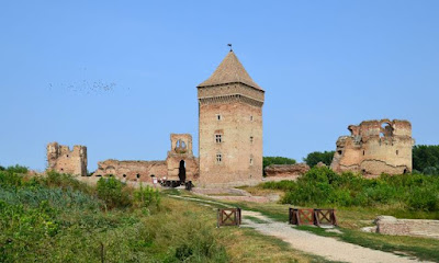
Located on the outskirts of a small town in northern Serbia, Bač Fortress is the most important medieval monument in the province of Vojvodina. There are records of a fort at the site dating back to at least the 9th century. The fortress originally stood on a historical island on the Mostonga river—back in those days, it was only approachable by drawbridge. The fortress that stands in Bač today was built by the Hungarian king Charles I in the 14th century. The castle complex originally had eight towers, along with residences, a chapel, well, barn, cistern and storage buildings.


Bač Fortress changed hands several times, and has been possessed at various points in time by the Kingdom of Hungary, the Ottoman Empire, the Habsburg Monarchy, and the Kingdom of Yugoslavia. In 1704, the fortress was badly damaged and largely abandoned. In 1948, Bač Fortress was declared a cultural monument, and a plan was developed to preserve and restore the historic building.

During the restoration process, work has focused on preserving archaeological remains and helping visitors appreciate the wider cultural landscape of Bač. The project was awarded the 2018 Europa Nostra Award, the European Union’s prize for cultural heritage.

Historically, the town of Bač has been a major crossroad point. Historians say that the region used to be one of the most developed parts of the Kingdom of Hungary. Artifacts found in the region suggest that it has been occupied by humans for nearly 8,000 years. Today, Bač is a unique mosaic of European cultures, containing buildings from the 12th to the 19th centuries with influences ranging from Romanesque, Gothic, Renaissance, Byzantine, and Islamic art.


16 September 2022 - ANCIENT LOMBARD TOWER - CATINO, ITALY


ANCIENT LOMBARD TOWER

 - CATINO, ITALY -


G'day folks,

This seventh-century fortification marked the western border of the Lombard duchy of Spoleto.  

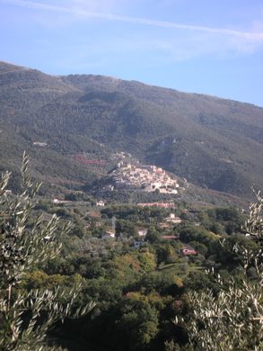
On the foothills of the Sabine mountains, overlooking the countryside that stretches all the way to Rome, a solitary tower stands guard above the hamlet of Catino, which is part of the town of Poggio Catino.

Poggio Catino is named after the enormous karstic sinkhole that hides beneath the hamlet and has helped make the site a formidable fortress. In the early Middle Ages, the area marked the border between the Roman/Byzantine territory of Rome and the Lombard duchy of Spoleto, and one of the main thoroughfares through the mountains.


The ruins of the fortress, which is mentioned in the work of the town’s most famous citizen, Gregorio da Catino, in his Regestum Farfense, are perched on an outcrop above the hamlet and surround a central keep, with an enormous pentagonal tower (108 feet tall) and that seems unassailable. It’s also survived earthquakes of the past few centuries.

That may not have been by accident. To make the tower lighter and more resilient, the Lombard lords had the upper section built of spongolite, a stone made from fossilized sponges, which could be extracted nearby.


4 September 2022 - ENORMOUS SINKHOLE IN ITALY


ENORMOUS

 SINKHOLE

 IN ITALY 


G'day folks,

This enormous sinkhole hides a secret world created from divine wrath.  

The mountains and forests surrounding the medieval village of Roccantica are wild and lush. They also hide several beautiful sights, such as hermitages and waterfalls but above all, the enormous and unusual sinkhole locally known as “U’revotano.”

This enormous abyss is a common geological phenomenon in Central Italy, also known as doline, in which karstic processes of erosion cause the collapse of a limestone roof over an underground cavern. This natural occurrence has inspired a local legend in which a village is known as Revotano.


According to local tradition, the village was inhabited by blasphemous residents and was swallowed up by divine wrath. As the story goes, the young wife of a local inhabitant who had gone to the stream to wash her laundry with her son suddenly heard a voice. The voice warned that divine punishment was going to befall her village. A great earthquake shook the land and the voice-guided them to safety. Revotano was swallowed into the sinkhole

The abyss is 820 feet (250-meters) wide and 426 feet (130 meters) deep. There are a few viewpoints that provide an understanding of the enormity of the sinkhole. A slippery, unmarked trail leads (with the help of a few ropes) to the bottom of the sinkhole where a fragile world of moss-carpeted trees and boulders resides.

The air is colder and more humid at the bottom of the sinkhole, allowing the moss and ferns to grow lush and in vivid hues. As this is a very fragile and unusual example of nature, take special care not to damage the vegetation when visiting. 


26 September 2022 - MEDIEVAL FRESCOES REVEALED DURING WW11


MEDIEVAL FRESCOES 

REVEALED 

DURING WW11


G'day folks,

When occupying Nazi troops detonated a mine below, medieval frescoes were revealed in this small cliff-side hermitage in Italy.  

The Eremo di San Cataldo (Hermitage of Saint Cataldus) is built into a steep cliff by the road connecting Contigliano to Cottanello in the region of Sabina, northeast of Rome.

Its origins are unclear, and some historians believe that it could date back as far as the 10th century, a time when the nearby Abbey of Farfa controlled the region. However, it is first mentioned in the 16th century, along with the attribution to Saint Cataldus, seventh-century Bishop of Rochau and patron saint of the southern city of Taranto. The reason for this connection is obscure, and many theories have been discussed as to why this saint was chosen.

The present staircase to the site was built in 1888, along with the main road. It leads to the church, the only structure that survives today, partially dug into the rock.


The church plan is rather simple, with a vestibule and a frescoed chapel with an altar made of the famous local red marble from Cottanello (which was also used in the construction of St. Peter’s Basilica in the Vatican), crowned by an upper floor with a bell tower.

The 11th- and 12th-century frescoes were discovered by chance after 1944, when the Germans detonated a mine on the road below, shattering the plaster holding Baroque frescoes that had been painted over them in the 17th century. The older, more valuable frescoes beneath include a remarkable Redeemer fresco, on the left side of the chapel, painted in a very Byzantine style. A Greek tau symbol painted in the fresco has been attributed to St. Francis, who traveled widely in Sabina, where he founded four monasteries. 

25 September 2022 - THE CHURCH IN THE SKY - ETHIOPIA


THE CHURCH 

IN THE SKY

 - ETHIOPIA -


G'day folks,

Reaching the "Church in the Sky" requires scaling the cliff face of a sandstone pinnacle with a 650-foot drop. 

If you think going to a normal church can be an enlightening experience, imagine going to worship in a rock-hewn painted cave atop a towering sandstone pinnacle, only reachable via a daredevil climb with 650-foot drops on all sides. 


At Abuna Yemata Guh in northern Ethiopia, this risky and thrilling experience is common practice for a few dedicated priests. The monolithic place of worship is said to be the world’s most inaccessible and dangerous church, reachable only by a 45-minute ascent.

The journey has cliff faces to scale, rickety bridges to cross, and narrow ledges to traverse. After crossing through the valley that underlies the church, you must ascend the half-mile-high sandstone pinnacle, searching for rare footholds to avoid the long drop. Adding to the general sense of dread, the route passes by an open-air tomb filled with the skeletal remains of deceased priests (although it’s said that none of the priests died from falling off the cliff).

If the intense climb and the gorgeous view of the valley below aren’t enough to take your breath away, the interior of the church surely will. The cave’s ceiling is covered by two beautiful frescoes, featuring intricate patterns, religious imagery, and the faces of nine of the twelve apostles of Christ. The church also contains an Orthodox Bible with vibrant, colorful sheets made of goatskin. Abuna Yemata Church is so sacred that some Ethiopian parents even risk bringing their babies all the way to the top of the cliff to have them baptized there.


The church is named after Father Yemata, a priest who carved the church out of the cliff face in the 5th century. Some say he chose the high location to escape enemies, while others believe it was an attempt to find true divinity. Either way, his rock-hewn masterpiece has provided a unique opportunity for Ethiopian Christians to demonstrate their commitment to their faith in epic fashion.

12 September 2022 - THE HOTTEST PLACE ON EARTH - ETHIOPIA


THE HOTTEST PLACE 

ON EARTH 

- ETHIOPIA -


G'day folks,

Welcome to the hottest place on the planet. 

In the north of Ethiopia, hours from any populated area, is a vast expanse of brutal landscape unlike anywhere else in the world.

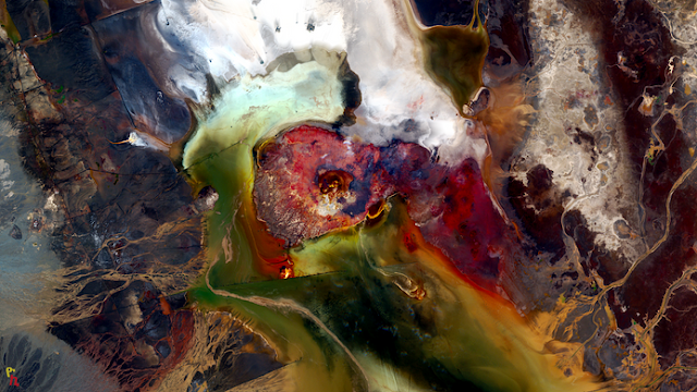
Dallol, in the Danakil Depression, is a boiling, salt-formed world completely hostile to human visitors. The Danakil Depression, also known as the Afar Depression, holds the distinction of being one of the lowest and hottest parts of the world.


On top of average temperatures of 94 degrees Fahrenheit, Dallol itself is surrounded by boiling hot springs, bringing hot minerals and toxic gas bubbles to the surface. Despite making Dallol uninhabited, these geological forces have actually made the area somewhat picturesque, coloring the lowlands with rusty orange, yellow, and green salt formations.

Dallol is extremely unwelcoming to inhabitation. However, a number of people have still ventured into the region for work, due to the high deposits of table salt in the area. Expeditions funded by Europe prior to World War I were shut down and dismantled throughout the first half of the 20th century. Later attempts by American, Indian, and Italian companies have resulted in thousands of mines throughout the region, but no permanent settlement.

Although it is now uninhabited, small structures made of salt bricks were created by the Afar people, when they were employed by mining companies throughout the 20th century. However, the majority of these have been abandoned and few traces of these settlements still exist.

Near the Dallol area in the same region is Erta Ale, the “Gateway to Hell,” a smoking volcanic terrain complete with its own lava lakes. It is an equally harsh and unforgiving environment, and nearly impossible to reach without great difficulty.


11 September 2022 - FIRE MEETS ICE AT Mt. EREBUS - ANTARCTICA


FIRE MEETS ICE 

AT Mt. EREBUS

 - ANTARCTICA -


G'day folks,

Fire meets ice at the southernmost volcano on Earth. 

Erebus. It’s a good name for the volcano. In Greek myth, Erebus was the son of the god Chaos, and his mother was Gaia or Earth. Erebus was made of darkness and shadow, and he filled the corners of the world with his darkness.

Currently, the most active volcano in Antarctica and the southernmost active volcano on Earth, the Mt. Erebus volcano features a 1,700-degree Fahrenheit lava lake, a swirling pool of magma that may be many miles deep: one of only five such lava lakes that exist in the world.


While the inside of Mt. Erebus may be extremely hot, outside of it, one would quickly freeze to death in the Antarctic temperatures. Riddling the side of the snow-covered volcano are ice caves, carved out by the escaping volcanic gases. Because of the gas, the ice caves stay a consistent 32 degrees, making them a likely spot for undiscovered extremophiles. The volcanic gases heat their way through these ice caves and escape into the air to form enormous 60-foot chimneys of ice, or “fumaroles” with deadly volcanic gases pouring out from their tips.

Discovered in 1841 by polar explorer Sir James Clark Ross, it was easy to identify Mt. Erebus as a volcano as it was erupting at the time. (Ross Island, which Mt. Erebus is on, is named after him as is the Ross Ice Shelf.) Later, polar explorer Ernest Shackleton would make the first ascent of Mt. Erebus between 1907-1909 on the Nimrod Expedition.

One of the things that makes Erebus significant - and the reason it is the location of the Mount Erebus Volcano Observatory, or “MEVO” - is that Erebus is one of only a few consistently active volcanos in the world. Rather than lying dormant and then spectacularly erupting once every few hundred years, though it does that on occasion too, Mt. Erebus is always on, bubbling, releasing gas and flinging ten feet wide “volcanic bombs” - hunks of molten rock which sometimes explode on landing - through the air. For a vulcanologist, Mt. Erebus is a dangerous but dreamy research site.

Mt. Erebus is also the site of a famous and tragic air disaster. An Air New Zealand DC-10 airliner on a sightseeing flight became lost in a whiteout and crashed into the side of the volcano on 28 November 1979, killing all 237 passengers and 20 crew. Famed explorer Sir Edmund Hillary was supposed to have been on board but canceled at the last moment.

Debris from the crash is still visible on the volcano, despite an extensive recovery and clean up the mission. The unclaimed remains of the crash victims are entombed at a memorial at the Waikumete Cemetery in West Aukland, New Zealand where every year a wreath is laid in memory.


3 September 2022 - THE SMOKING HILLS - CANADIAN ARCTIC


THE SMOKING HILLS 

- CANADIAN ARCTIC -


G'day folks,

These hellish-looking cliffs in the Canadian Arctic have been burning for centuries. 

Located on the Arctic Ocean in Canada’s Northwest Territories, these barren red-striped rocks have been burning continuously for centuries. This smoldering hellscape is aptly known as the Smoking Hills, and it must have been a shocking sight for the first European sailors to approach this strange remote landscape.

The first recorded sighting of the burning hills was by the Irish explorer Captain Robert McClure in the early 1800s. His crew had journeyed to the Canadian Arctic searching for the lost explorer Sir John Franklin, who disappeared five years earlier on an expedition to map the Northwest Passage. (According to the stories, when McClure brought a piece of the smoking rock back to the ship it burned a hole through his wooden desk.)


The explorers believed volcanic activity was causing the hills to burn, but in fact there is another explanation. The underground oil shales in the area are rich in sulfur and brown coal, causing the rock to spontaneously ignite when the hills erode and expose the combustible gases to oxygen.

Over the years, the sulfur dioxide produced from the combustion has changed the acidity of the area to such a degree that it’s now a different ecosystem than the surrounding landscape. And the normally dark mudstone is baked and bleached by the heat, coloring the cliffs with stripes of red and orange.

Thanks to this strange natural phenomenon, it’s likely these Arctic hills were burning with thick plumes of smoke for centuries before the European expeditions. Indeed, local indigenous populations have long come to the area to gather coal. The nearest community (which is over 60 miles away) is called Paulatuk, which means “place of soot” or “place of coal” in the Inuvialuktun language.

20 September 2022 - SALTY LAKE ABBE - DJIBOUTI


SALTY LAKE ABBE 

- DJIBOUTI -


G'day folks,

Welcome to a salt lake dotted with steaming limestone chimneys. 

Situated in the middle of the hot and hellish Afar Depression, Lake Abbe stretches six miles in width and is covered in clusters of massive, steam-blasting limestone chimneys.

Although Lake Abbe is the ultimate destination for Ethiopia’s Awash River, its dry landscape absorbs the water, and the area is a vast landscape of salt flats. Besides Mount Dama Ali, a small dormant volcano, the landscape is almost completely level, and the steaming, sulphuric vents lend the region an apocalyptic, and Tatooine-like look. 


Some of the vents stretch as high as 150 feet into the air, and make the lake visible from miles around. Despite the hellish climate near Lake Abbe, nomadic Afar shepherds live in the area, along with a surprising population of flamingos.